From Huron Street to Research Journal by Drone
Urban heat research using drone-based thermal visualization builds the case for how we can build cooler cities.
When I started my urban heat research in 2019, I had no idea how far it was going to take me. But the drones have taken me from Ann Arbor to Omaha to Europe and back again, and it was particularly rewarding to have this work published in the peer-reviewed Journal of Urban Affairs (JUA).
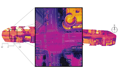
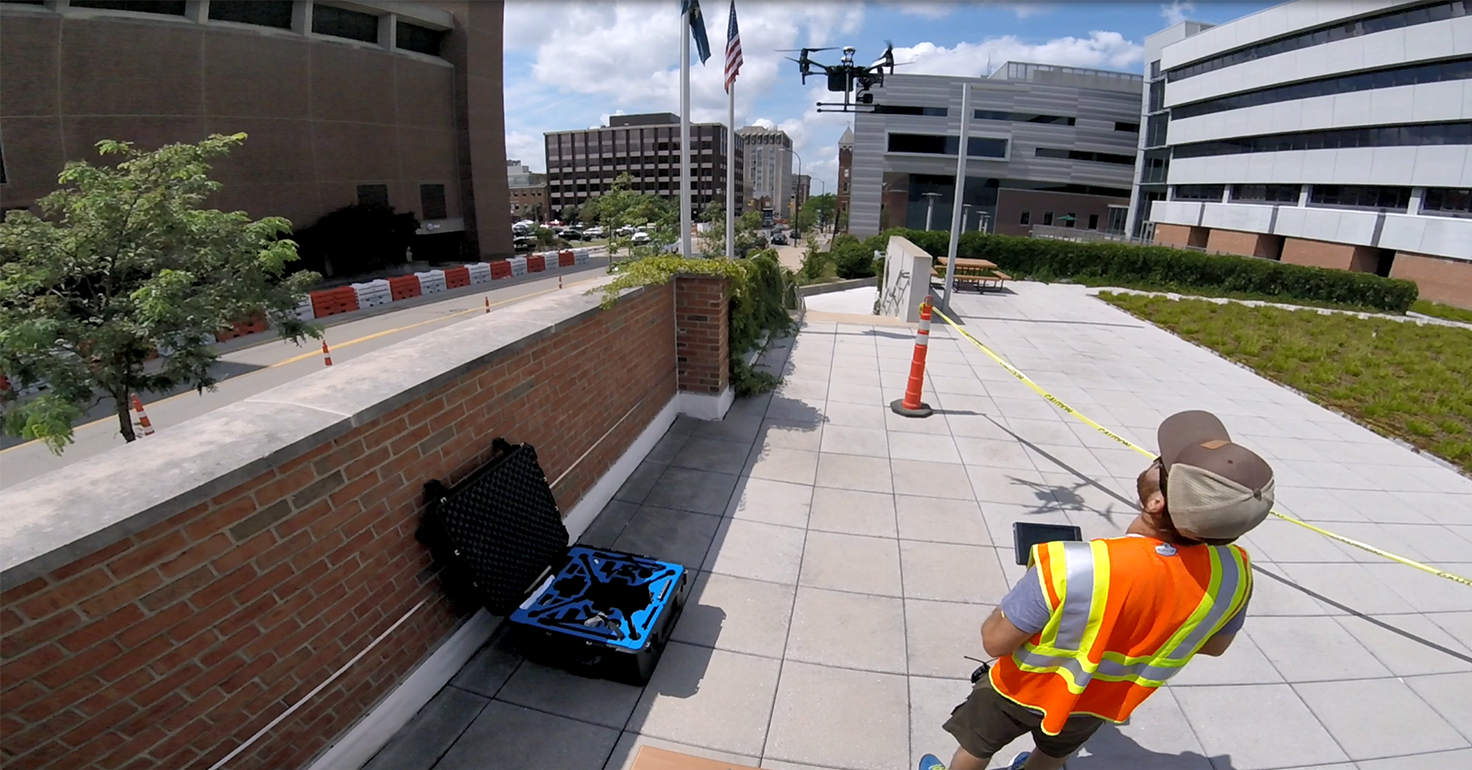
Using drones equipped with thermal cameras, my work aims to help cities understand and reduce the urban heat island effect — a phenomenon where cities become significantly warmer than surrounding areas due to heat-retaining materials like asphalt, concrete, and black rooftops. While satellites have been used to track urban heat on a broad scale, their resolution (each pixel = 30x30 meters) is too coarse to analyze specific streets or materials. Drones, however, can capture detailed images at a resolution of less than 1.5 cm per pixel, offering a much more detailed understanding.
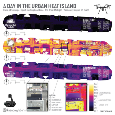
The JUA article focuses on research conducted for a five-block revitalization project along Huron Street in downtown Ann Arbor, Michigan. The city planned to reduce heat and improve comfort by adding shade trees, green space and updated sidewalk materials. The drone scans were used to capture before-and-after thermal imagery to evaluate the project's impact. Initial scans took place before construction in 2019 and after in 2020, with another set of scans conducted in 2024.
The key research goals were to:
- Understand how different urban materials behave thermally.
- Measure temperatures of surfaces during peak heat at solar noon.
- Quantify how heat levels change throughout the day (diurnal variation).
What the Research Findings Show
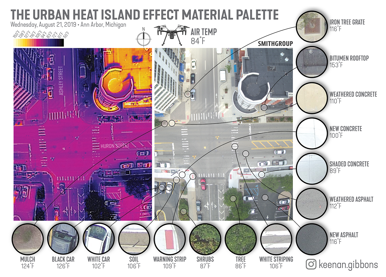
Material Matters
Different surfaces absorb and retain heat in different ways. Vegetated areas and shaded spots remained near air temperature (about 84°F), while exposed concrete was 20°F hotter. Dark rooftops and asphalt roads reached up to 174°F — more than 90°F hotter than the air.
Shade is Powerful
Trees and building shade helped keep surface temperatures low. Even new, lighter-colored concrete was cooler than older, darker slabs.
Heat Persists at Night
Heat stored in urban surfaces does not disappear after sunset. Materials like asphalt and rooftops retain heat after sunset, contributing to human discomfort and higher cooling needs.
Unplanted Green Spaces Get Hot
Areas that were designed for plants but left unplanted (e.g., exposed mulch beds, soil, etc.) showed extreme heat levels, highlighting the need for both planning and ongoing maintenance.
An Essential Tool for Urban Planning and Policy
Drones offer an accessible, high-resolution way to evaluate the effectiveness of heat mitigation strategies, and to inform better choices in materials, plantings and zoning regulations. Planners can use them to prioritize shade, green space and thoughtful material selection to reduce the heat burden on urban populations — especially as cities face rising temperatures.
My study also suggests that urban heat should be treated as a public health issue, with policy interventions aimed at reducing life-threatening surface temperatures. Long-term monitoring, using both aerial and ground-based tools, will be essential for tracking the success of our urban cooling strategies.
The next phase of my research will shed even more light on what we can do to adapt our cities to extreme heat. I plan to complete my post-construction analysis of Huron Street in the coming year, and to share my findings as part of our collective journey towards planning, designing and building cooler, healthier cities.
Read the full NUA article here.
Listen to an NPR One interview with Keenan on "Measuring streetscape heat islands in Ann Arbor" here.